


Hailey Hill
Science and Technology Editor
The start of winter quarter at the UC, Santa Barbara (UCSB) was marked by significant storm activity that resulted in flooded streets, damaged infrastructure, and cancellation of classes and campus closures on Jan. 9 and 10.
As Santa Barbara’s trademark sunny skies and idyllic weather make a welcomed return, it’s easy to assume that the risks posed to the local community have dissipated, especially now that the rain has subsided and the flood water has drained away. However, there is an underlying consequence of the recent storms that continues to pose a significant risk to the UCSB community and its neighboring community of Isla Vista (I.V.): cliff erosion.
UCSB and I.V. are both situated along the top of steep bluffs that give striking panoramic views of the Pacific Ocean, but such proximity to the ocean is not without risk. The steep, rocky cliff sides are in almost constant contact with battering ocean waves, which increase in force when storm activity triggers strong winds and higher tides. These factors all contribute to erosion, a process wherein natural forces, such as wind or water, wear down features of a landscape over time. Cliff erosion ultimately causes loss of land as the cliffs are no longer stable enough to support the geographical features and infrastructure above.
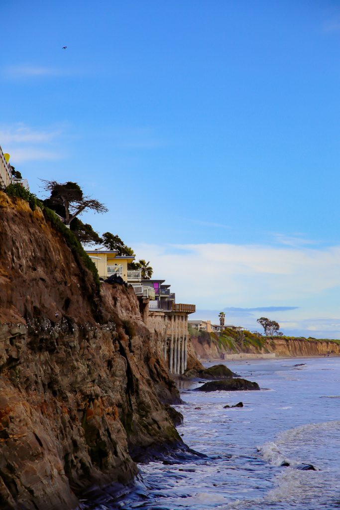
Erosion has already altered the coastal landscape of UCSB and Isla Vista in drastic ways over the past several decades. For example, most student residents of Isla Vista would be surprised to learn that there used to be a complete bike path along the bluffs behind the houses and apartment buildings of oceanside Del Playa Drive. This is hard to imagine considering the state of the Del Playa bluffs today where steep, jagged cliff sides meet critical residential infrastructure with precarious closeness. Geological researchers estimate that our local coastal bluffs have been eroding at an average rate of 2-14 inches per year, underscoring the constant change of the local coastline.
The recent storms battered these already-fragile coastal cliffs with strong surf and winds, exacerbating the risk to infrastructure that relies on the cliffs remaining stable. Residents of oceanside Del Playa Drive received official notices on Jan. 3 that their properties were being monitored by Santa Barbara County for potential “bluff failure,” and that residents were advised to avoid “[going] out on the bluffs or bluff top decks/patios.” During the storms and the days that followed, Coast Guard helicopters were seen flying along the coastline to check for immediately observable damage.
To the relief of local residents, the cliff sides have remained stable thus far. However, minor damages are evident, particularly on the beaches underneath the cliffs where large rocks and debris knocked loose by the tidal surges still litter the sand. However, the risk of a larger landslide or bluff collapse remains, especially since climate change is believed to be worsening such erosion rates.
In recent years, several oceanside Del Playa properties have had to scale back decks in order to maintain space from the cliffs’ edge, install taller, stronger boundary fences, or even demolish units that were at risk of falling victim to erosion. Such projects are vital to maintaining the livability of these properties for as long as possible, especially in the midst of a housing shortage for UCSB students. With this housing crisis and increasingly extreme weather in mind, we can expect that the community of I.V. will continue to see significant changes in the coming years.